Large parts of the province could experience “significant” flooding in the coming days, according to an expert monitoring flood levels.
David Chapman, head of the River Forecast Centre, said British Columbia’s Interior typically experiences flooding around this time of the year as the snow melts, adding that current flood conditions are “moderate” in comparison. But the province is also experiencing a “rapid transition” into spring thanks to high temperatures with some areas hitting 30 degrees Celsius and moderate to heavy rain in the forecast later this week.
“When you look at the forecast for the coming weather, there is some concern that the combination of accelerating snowmelt we got as well as rainfall within some of those regions that we have identified as under flood watches and warnings, we do have the potential for very significant flooding through the weekend,” he said.
Current conditions point to flooding seen every 10 to 20 years, he added.
“But there are some scenarios (where) we get higher rainfalls that can be higher than that.”
Chapman made these comments during an update where Emergency Management Minister Bowinn Ma updated media on current and future flooding conditions. As of noon Thursday (May 4), officials have issued seven evacuation orders and six evacuation alerts.
While the flooding situation across the province is still evolving, the potential geographic scale is immense. A large stretch of B.C.’s southern Interior is either under a flood watch with river levels rising or under a flood warning with river levels either on the brink of overflow, or already overflowing. The area affected runs from Manning Park east of Hope to the Alberta border, and from 100 Mile House in the north to Grand Fork near the U.S. border, and is home to 100,000s of people.
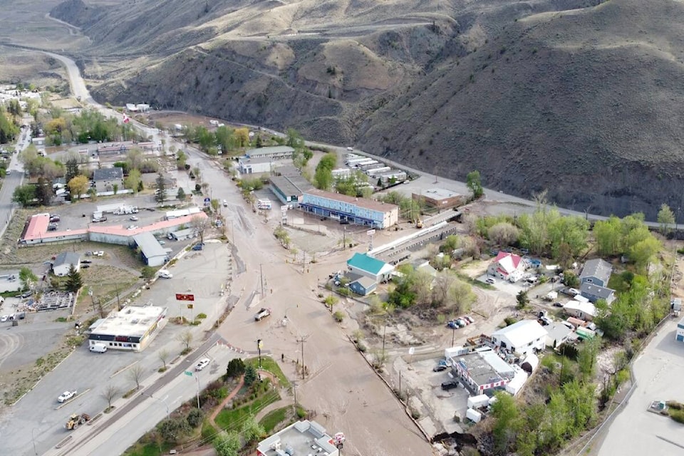
But no community has been hit harder than Cache Creek, where flooding has impacted crucial infrastructure. Ma said provincial officials are working hard with municipal staff to coordinate the response, having deployed sandbags, sandbag machines, temporary retaining walls and emergency flood barriers to the community.
“The people of Cache Creek are facing an immense challenge,” Ma said. “It’s a very scary situation to see the community flooded like that.”
RELATED: Cache Creek a raging river as flooding puts several B.C. communities on alert
RELATED: Aerial view of destructive flooding in Cache Creek
RELATED: VIDEO: Flooding causes extensive damage at Parker Cove on Westside
RELATED: Flooding, mudslide closes Highway 3 in two Kootenay locations
RELATED: Higher temperatures followed by heavy rains mean more B.C. flooding in coming days
Residents received a piece of good news when a Ministry of Transportation official told media Cache Creek has retreated to its culvert, allowing crews to assess damage to Highway 97, which had closed two days ago. It remains closed as off Thursday afternoon. Highway 1 also remains closed.
Another community keeping a close eye on water levels is Grand Fork in B.C.’s Boundary Country. Like Cache Creek, the community has experienced flooding in 2018, prompting improvements to the local dike system. Ma said these improvements have Grand Forks in a far better place right now. But she also acknowledged a weakness in the dam that staff hope to plug this weekend.
Ma’s ministry said the work involves upgrading stormwater drain lines and a on the downtown dike where these pipes run through the dike. “Construction work on this section is advancing toward completion by Friday, ensuring that the work continues to meet dike engineering requirements,” it reads. “Alternate emergency plans will be put in place in the event of any construction delays.”
Another area of concern is the western side of Lake Okanagan. Ma said the Okanagan Indian Band is likely to be cut off because of flooding and Transportation Minister Rob Fleming said the community may have to be supplied by water rather than road.
Another parts of the province watching closely is Merritt in the Nicola Valley, where both the Coldwater River and the Nicola River have been running at higher levels for days.
Officials in Merritt said Tuesday (May 2) that are they monitoring the situation in pointing out that both the Nicola and Coldwater remain within normal flows for this time of year.
“Water levels may rise further due to the melting snow pack, but we do not anticipate any flooding in Merritt at this time,” it reads.
@wolfgangdepner
wolfgang.depner@blackpress.ca
Like us on Facebook and follow us on Twitter.